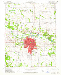
1963 Map of Carthage
USGS Topo · Published 1964About this map
Carthage stands as the industrial and civic anchor of this 1963 landscape, where the confluence of the Spring River and major rail lines defined its growth. The map reveals a dense network of educational and religious institutions, including Our Lady of the Ozarks College and several parochial and public schools like Eugene Field Sch and Columbian Sch. Outside the city center, the terrain is marked by extractive industries, notably the numerous Quarries and Gravel Pits that suggest the region's reliance on mineral resources.
Find a feature on this map
56 named features on this map. Tap any name to fly to it.
Don’t see what you’re looking for? This feature index may not catch every label — zoom into the map to look around manually.
Map Details
Editions of this 1963 Carthage Map
2 editions found
Other maps of this area
1886 · Carthage
USGS Topo · 1:125,000
1894 · Carthage
USGS Topo · 1:125,000
1921 · Sarcoxie
USGS Topo · 1:62,500

1947 · Joplin
USGS Topo · 1:250,000
1949 · Joplin
USGS Topo · 1:250,000
1954 · Joplin
USGS Topo · 1:250,000
1958 · Joplin
USGS Topo · 1:250,000
1959 · Joplin
USGS Topo · 1:250,000
1962 · Jasper
USGS Topo · 1:24,000
1962 · Neck City
USGS Topo · 1:24,000