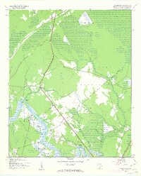
1943 Map of Carvers Bay
USGS Topo · Published 1963About this map
The Black River defines the southwestern edge of this 1943 landscape, winding through a network of wetlands and landings that historically supported the regional timber and agricultural economy. The Roland Hall Plantation stands near the riverbank, a vestige of the area's older land-use patterns, while the nearby Dunbar Landing and Post Foot Landing indicate the ongoing importance of river access. Much of the northern interior is dominated by the U S Army Reservation, which encompasses the broad, swampy expanse of Carvers Bay and Machine Bay. Settlements like Annieville, Allentown, and Dunbar are scattered along the primary roads, often centered around community landmarks such as Hopewell Ch and St Marys Ch. This survey, produced during the war years, documents a period when the rural backcountry of Georgetown County balanced traditional river-oriented life with modern military land use.
Find a feature on this map
29 named features on this map. Tap any name to fly to it.
Don’t see what you’re looking for? This feature index may not catch every label — zoom into the map to look around manually.
Map Details
Editions of this 1943 Carvers Bay Map
3 editions found
Other maps of this area

1942 · Waverly Mills
USGS Topo · 1:24,000

1943 · Olin
USGS Topo · 1:31,680

1943 · Yauhannah
USGS Topo · 1:24,000

1943 · Henry
USGS Topo · 1:24,000

1943 · Carvers Bay
USGS Topo · 1:24,000

1943 · Plantersville
USGS Topo · 1:24,000

1943 · Rhems
USGS Topo · 1:24,000

1943 · Georgetown North
USGS Topo · 1:24,000

1943 · Outland
USGS Topo · 1:24,000

1944 · Outland
USGS Topo · 1:31,680