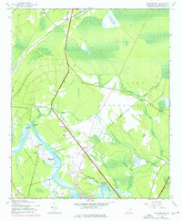
1943 Map of Carvers Bay
USGS Topo · Published 1976About this map
Black River meanders through the heart of this coastal South Carolina landscape, defining a region of dense wetlands and historic landings. During the early 1940s, the terrain was characterized by a complex network of waterways, including Choppee Creek, Furdick Creek, and Peters Creek, alongside engineered features like Machine Bay and various drainage ditches. The map reveals the proximity of rural life to military activity, as the U S Army Reservation occupies a significant portion of the eastern woods and bays.
Find a feature on this map
30 named features on this map. Tap any name to fly to it.
Don’t see what you’re looking for? This feature index may not catch every label — zoom into the map to look around manually.
Map Details
Editions of this 1943 Carvers Bay Map
3 editions found
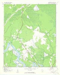
Other maps of this area

1942 · Waverly Mills
USGS Topo · 1:24,000

1943 · Olin
USGS Topo · 1:31,680

1943 · Yauhannah
USGS Topo · 1:24,000

1943 · Henry
USGS Topo · 1:24,000

1943 · Carvers Bay
USGS Topo · 1:24,000

1943 · Plantersville
USGS Topo · 1:24,000

1943 · Rhems
USGS Topo · 1:24,000

1943 · Georgetown North
USGS Topo · 1:24,000

1943 · Outland
USGS Topo · 1:24,000

1944 · Outland
USGS Topo · 1:31,680