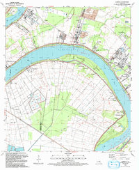
1992 Map of Carville
USGS Topo · Published 1992About this map
The Mississippi River creates a massive, sweeping curve that defines this riverfront landscape at the borders of Iberville and Ascension Parishes. A significant medical landmark, the Gillis W Long Hansens Disease Center, occupies a prominent bend near Carville. The area's agricultural and industrial heritage is evident in the transition from historic grounds like the Mulberry Grove Plantation to modern energy infrastructure. The Willow Glen Oil Field and Rocky Mountain Oil and Gas Field reflect the subsurface resources of the region, while a series of Industrial Waste Ponds and a Waste Treatment Facility suggest the evolving industrial footprint of the late 20th century. Numerous small communities and churches, such as Hohen Solms and St Phillip Ch, dot the levee-protected lands, connected by the historic Carville-White Castle Ferry.
Find a feature on this map
47 named features on this map. Tap any name to fly to it.
Don’t see what you’re looking for? This feature index may not catch every label — zoom into the map to look around manually.
Map Details
Editions of this 1992 Carville Map
This is the sole edition of this map. No revisions or reprints were ever made.
Other maps of this area

1892 · Donaldsonville
USGS Topo · 1:62,500

1908 · Baton Rouge
USGS Topo · 1:62,500

1934 · Denham Springs
USGS Topo · 1:62,500

1935 · Gonzales
USGS Topo · 1:31,680

1936 · White Castle
USGS Topo · 1:62,500

1939 · Denham Springs
USGS Topo · 1:62,500

1939 · Baton Rouge
USGS Topo · 1:62,500

1939 · Donaldsonville
USGS Topo · 1:62,500

1947 · Donaldsonville
USGS Topo · 1:31,680

1953 · Plaquemine
USGS Topo · 1:24,000