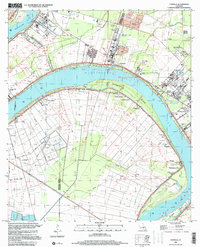
1999 Map of Carville
USGS Topo · Published 2000About this map
Mississippi River meanders sharply through the Louisiana sugar belt at the turn of the millennium, defining a landscape of industrial sites and deep-rooted river settlements. The west bank is characterized by the crescent of Claiborne Island and the community of Hohen Solms, while the east bank at Carville is home to the Gillis W Long Center. This area illustrates the long-standing transition from agricultural estates like Mulberry Grove Plantation to heavy industrial operations, evidenced by numerous tailings ponds and waste facilities that now sit adjacent to older river landings.
Find a feature on this map
47 named features on this map. Tap any name to fly to it.
Don’t see what you’re looking for? This feature index may not catch every label — zoom into the map to look around manually.
Map Details
Editions of this 1999 Carville Map
This is the sole edition of this map. No revisions or reprints were ever made.
Other maps of this area

1892 · Donaldsonville
USGS Topo · 1:62,500

1908 · Baton Rouge
USGS Topo · 1:62,500

1934 · Denham Springs
USGS Topo · 1:62,500

1935 · Gonzales
USGS Topo · 1:31,680

1936 · White Castle
USGS Topo · 1:62,500

1939 · Denham Springs
USGS Topo · 1:62,500

1939 · Baton Rouge
USGS Topo · 1:62,500

1939 · Donaldsonville
USGS Topo · 1:62,500

1947 · Donaldsonville
USGS Topo · 1:31,680

1953 · Plaquemine
USGS Topo · 1:24,000