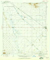
1924 Map of Casa Grande
USGS Topo · Published 1924About this map
The Gila River landscape in the early 1920s is defined by a complex network of seasonal washes and early irrigation infrastructure. The Southern Pacific railroad cuts diagonally across the desert floor, passing through small rail sidings like Bon and Nunez before reaching the growing settlement of Casa Grande. This era captures the transition from traditional desert living to modern water management, evidenced by the presence of the Casa Grande-Florence Canal and the USRS Pump Sta. These developments hint at the agricultural expansion that would soon transform the region.
Find a feature on this map
18 named features on this map. Tap any name to fly to it.
Don’t see what you’re looking for? This feature index may not catch every label — zoom into the map to look around manually.
Map Details
Editions of this 1924 Casa Grande Map
This is the sole edition of this map. No revisions or reprints were ever made.
Historical Maps of Maricopa Through Time
3 maps found