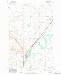
1983 Map of Cascade
USGS Topo · Published 1983About this map
Cascade sits along the west bank of the Missouri River, serving as a central hub for the surrounding ranching and river country in the early 1980s. The landscape is defined by the sharp transition from the river bottomlands of Chestnut Valley and Lower Chestnut Valley to the prominent rising form of Cascade Butte. This survey highlights the critical infrastructure of the era, notably the Burlington Northern railroad corridor and the St Peter Mission Road which heads west toward the mountains.
Find a feature on this map
22 named features on this map. Tap any name to fly to it.
Don’t see what you’re looking for? This feature index may not catch every label — zoom into the map to look around manually.
Map Details
Editions of this 1983 Cascade Map
This is the sole edition of this map. No revisions or reprints were ever made.
Other maps of this area

1886 · Great Falls
USGS Topo · 1:250,000

1949 · Cascade
USGS Topo · 1:62,500

1951 · Cascade
USGS Topo · 1:62,500

1954 · Great Falls
USGS Topo · 1:250,000

1957 · Great Falls
USGS Topo · 1:250,000

1960 · Simms
USGS Topo · 1:62,500

1961 · Hardy
USGS Topo · 1:24,000

1961 · Rocky Reef
USGS Topo · 1:24,000

1961 · Schrammeck Lake
USGS Topo · 1:24,000
1976 · Great Falls South
USGS Topo · 1:100,000