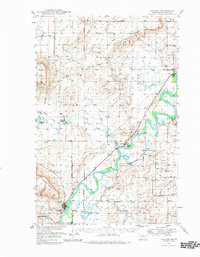
1949 Map of Cascade
USGS Topo · Published 1981About this map
Missouri River meanders through the heart of this post-war landscape, shaping the development of Cascade and Ulm. The irrigation infrastructure of the era is evident through the Rocky Reef Canal and St. Peters Mission Ditch, which support the agriculture of the Chestnut Valley. The influence of early aviation and local transportation is visible at the Private Airport and along the Great Northern rail line, which follows the river's path. Distinctive geological landmarks like Square Butte and Cascade Butte provide a backdrop to rural life, while smaller sites like Riverdale and the Superior Sch document the localized community structure. Genealogists may find particular interest in the Castner Falls Cem and the location of the Travis Sch Artesian Well, representing essential water sources for the period's homesteads and schools.
Find a feature on this map
31 named features on this map. Tap any name to fly to it.
Don’t see what you’re looking for? This feature index may not catch every label — zoom into the map to look around manually.
Map Details
Editions of this 1949 Cascade Map
2 editions found
Other maps of this area

1886 · Great Falls
USGS Topo · 1:250,000

1949 · Cascade
USGS Topo · 1:62,500

1949 · Great Falls
USGS Topo · 1:62,500

1949 · Vaughn
USGS Topo · 1:62,500

1950 · Fairfield
USGS Topo · 1:62,500

1951 · Great Falls
USGS Topo · 1:62,500

1951 · Cascade
USGS Topo · 1:62,500

1952 · Vaughn
USGS Topo · 1:62,500

1954 · Great Falls
USGS Topo · 1:250,000

1955 · Gore Hill
USGS Topo · 1:62,500