
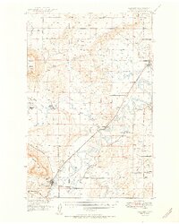
1951 Map of Cascade
USGS Topo · Published 1951About this map
The Missouri River snakes through this 1951 landscape, defining the corridor between the prominent heights of Square Butte and Cascade Butte. This post-war survey captures the rural infrastructure of central Montana, showing the transition of the land as the Great Northern railroad parallels the river through the settlements of Cascade, Riverdale, and Ulm. The map highlights the reliance on local water sources, noting numerous Springs and an Artesian Well near the Travis School.
Find a feature on this map
41 named features on this map. Tap any name to fly to it.
Don’t see what you’re looking for? This feature index may not catch every label — zoom into the map to look around manually.
Map Details
Editions of this 1951 Cascade Map
2 editions found
Other maps of this area

1886 · Great Falls
USGS Topo · 1:250,000

1949 · Cascade
USGS Topo · 1:62,500

1949 · Great Falls
USGS Topo · 1:62,500

1949 · Vaughn
USGS Topo · 1:62,500

1950 · Fairfield
USGS Topo · 1:62,500

1951 · Great Falls
USGS Topo · 1:62,500

1952 · Vaughn
USGS Topo · 1:62,500

1954 · Great Falls
USGS Topo · 1:250,000

1955 · Gore Hill
USGS Topo · 1:62,500

1957 · Great Falls
USGS Topo · 1:250,000