
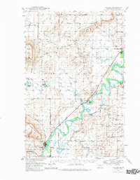
1949 Map of Cascade
USGS Topo · Published 1956About this map
Missouri River water rights and agricultural development define this mid-century landscape south of Great Falls. The Great Northern railroad parallels the river's eastern bank, connecting the settlements of Cascade, Riverdale, and Ulm. The maps's infrastructure reveals a focus on water management for ranching and transport, noted by the presence of the Elizabeth Reservoir (Aban'd) and Rocky Reef Reservoir.
Find a feature on this map
44 named features on this map. Tap any name to fly to it.
Don’t see what you’re looking for? This feature index may not catch every label — zoom into the map to look around manually.
Map Details
Editions of this 1949 Cascade Map
2 editions found
Other maps of this area

1886 · Great Falls
USGS Topo · 1:250,000

1949 · Great Falls
USGS Topo · 1:62,500

1949 · Vaughn
USGS Topo · 1:62,500

1950 · Fairfield
USGS Topo · 1:62,500

1951 · Great Falls
USGS Topo · 1:62,500

1951 · Cascade
USGS Topo · 1:62,500

1952 · Vaughn
USGS Topo · 1:62,500

1954 · Great Falls
USGS Topo · 1:250,000

1955 · Gore Hill
USGS Topo · 1:62,500

1957 · Great Falls
USGS Topo · 1:250,000