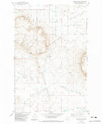
1983 Map of Cascade Colony
USGS Topo · Published 1983About this map
Cascade Colony serves as a focal point in this high plains landscape of central Montana, characterized by a complex system of irrigation and historic land divisions. The northern edge of the map reveals the critical role of water management in this semi-arid region, featuring the Fort Shaw Canal, a Flume, and a Pipeline that traverse the terrain near Hanson Coulee. The presence of the Old Fort Shaw Military Boundary cutting across the center of the sheet provides a tangible link to the 19th-century military presence in the Montana Territory, marking the edge of former reservation lands.
Find a feature on this map
22 named features on this map. Tap any name to fly to it.
Don’t see what you’re looking for? This feature index may not catch every label — zoom into the map to look around manually.
Map Details
Editions of this 1983 Cascade Colony Map
This is the sole edition of this map. No revisions or reprints were ever made.
Other maps of this area

1886 · Great Falls
USGS Topo · 1:250,000

1949 · Cascade
USGS Topo · 1:62,500

1949 · Vaughn
USGS Topo · 1:62,500

1950 · Fairfield
USGS Topo · 1:62,500

1951 · Cascade
USGS Topo · 1:62,500

1952 · Vaughn
USGS Topo · 1:62,500

1954 · Great Falls
USGS Topo · 1:250,000

1957 · Great Falls
USGS Topo · 1:250,000

1960 · Simms
USGS Topo · 1:62,500

1976 · Great Falls North
USGS Topo · 1:100,000