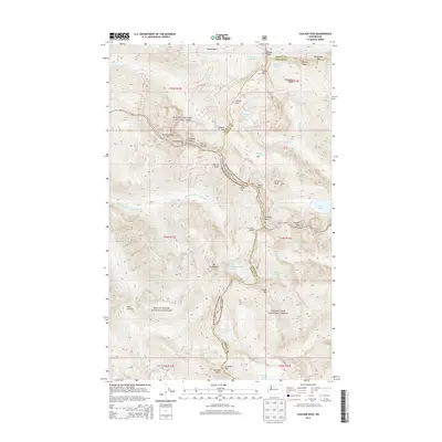
2014 Map of Cascade Pass
USGS Topo · Published 2014About this map
Cascade Pass serves as the central high-altitude crossing point on this survey, marking the intersection of North Cascades National Park, Mount Baker National Forest, and Wenatchee National Forest. The map documents a landscape defined by dramatic glaciated peaks and high alpine lakes at the boundary of Skagit and Chelan counties. High-elevation water systems are prominent, including the vast Boston Glacier and the Quien Sabe Glacier, which feed into drainage basins like the Stehekin River and the S Fork Cascade River. Mountaineering landmarks such as Johannesburg Mtn, Sahale Mtn, and the technical Sprenger Spires are detailed alongside remote water bodies like Doubtful Lake and the Yang Yang Lakes. The survey also captures the steep descent into Horseshoe Basin and the narrow passage through Box Canyon, illustrating the challenging connectivity of the northern Cascade Range.
Find a feature on this map
67 named features on this map. Tap any name to fly to it.
Don’t see what you’re looking for? This feature index may not catch every label — zoom into the map to look around manually.
Map Details
Editions of this 2014 Cascade Pass Map
This is the sole edition of this map. No revisions or reprints were ever made.
Other maps of this area

1899 · Glacier Peak
USGS Topo · 1:125,000

1901 · Glacier Peak
USGS Topo · 1:125,000

1902 · Stehekin
USGS Topo · 1:125,000

1904 · Stehekin
USGS Topo · 1:125,000

1920 · Slate Pass
USGS Topo · 1:125,000

1955 · Concrete
USGS Topo · 1:250,000

1958 · Concrete
USGS Topo · 1:250,000

1962 · Concrete
USGS Topo · 1:250,000
1963 · Agnes Mtn
USGS Topo · 1:24,000

1963 · Sonny Boy Lakes
USGS Topo · 1:24,000