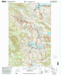
1999 Map of Cascade Pass
USGS Topo · Published 2002About this map
Cascade Pass serves as a critical geographic junction on this late-twentieth-century survey, marking the high divide where the North Fork Cascade River and Stehekin River headwaters diverge. This high-altitude landscape is defined by its glacial activity, with prominent features like Boston Glacier, Davenport Glacier, and Sahale Glacier crowning the peaks. The presence of the Diamond Mine near Sahale Mountain and another Mine further east suggests a history of mineral exploration in these remote elevations, even as the area is protected within North Cascades National Park and the Glacier Peak Wilderness. Named alpine features such as Doubtful Lake, Kool-Aid Lake, and Mount Formidable emphasize the isolation and challenging environment that characterize the Skagit and Chelan county line at the turn of the millennium.
Find a feature on this map
58 named features on this map. Tap any name to fly to it.
Don’t see what you’re looking for? This feature index may not catch every label — zoom into the map to look around manually.
Map Details
Editions of this 1999 Cascade Pass Map
This is the sole edition of this map. No revisions or reprints were ever made.
Other maps of this area

1899 · Glacier Peak
USGS Topo · 1:125,000

1901 · Glacier Peak
USGS Topo · 1:125,000

1902 · Stehekin
USGS Topo · 1:125,000

1904 · Stehekin
USGS Topo · 1:125,000

1920 · Slate Pass
USGS Topo · 1:125,000

1955 · Concrete
USGS Topo · 1:250,000

1958 · Concrete
USGS Topo · 1:250,000

1962 · Concrete
USGS Topo · 1:250,000
1963 · Agnes Mtn
USGS Topo · 1:24,000

1963 · Sonny Boy Lakes
USGS Topo · 1:24,000