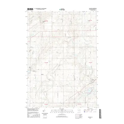
2015 Map of Cascade
USGS Topo · Published 2015About this map
Glacial landforms define the landscape south of Greenbush, where the Ice Age National Scenic Trail traverses the Parnell Esker and the Greenbush Kettle. This 2015 survey illustrates a rural terrain marked by family-named roads and scattered historic cemeteries, including Saint Michaels Catholic Cem and Union Cem. The settlement of Cascade sits along the Onion River, near the recreational waters of Lake Ellen and the surrounding Cascade Swamp. The drainage patterns here are complex, with the N Br Milwaukee River winding through the central portion of the quadrangle while smaller tributaries like Ben Nutt Cr and Watercress Cr feed the larger systems. To the west, the tiny community of Parnell serves as a local landmark amidst the drumlins and ridges that characterize this portion of Sheboygan County. The map provides a contemporary view of these traditional crossroads, where 1848 Settlement Ln still preserves the name of the era of early Wisconsin statehood.
Find a feature on this map
83 named features on this map. Tap any name to fly to it.
Don’t see what you’re looking for? This feature index may not catch every label — zoom into the map to look around manually.
Map Details
Editions of this 2015 Cascade Map
This is the sole edition of this map. No revisions or reprints were ever made.
Other maps of this area

1954 · Sheboygan Falls
USGS Topo · 1:62,500

1954 · Howards Grove
USGS Topo · 1:62,500

1954 · Franklin
USGS Topo · 1:24,000

1954 · Kiel
USGS Topo · 1:62,500

1954 · Milwaukee
USGS Topo · 1:250,000

1955 · Kewaskum
USGS Topo · 1:62,500

1957 · Madison
USGS Topo · 1:250,000

1958 · Milwaukee
USGS Topo · 1:250,000

1960 · Madison
USGS Topo · 1:250,000
1974 · Random Lake
USGS Topo · 1:24,000