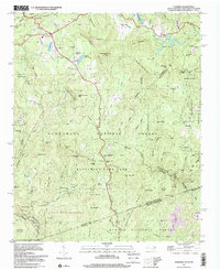
1997 Map of Cashiers
USGS Topo · Published 2001About this map
Cashiers and High Hampton serve as the primary focal points in this high-altitude landscape of the Blue Ridge, where the continental Divide Ridge dictates the flow of numerous headwaters. The map records a complex network of family and community history through landmarks like Upper Zachary Cem, Lower Zachary Cem, and Norton Cem, alongside rural institutions such as Heady Mountain Ch and Montvale Sch.
Find a feature on this map
86 named features on this map. Tap any name to fly to it.
Don’t see what you’re looking for? This feature index may not catch every label — zoom into the map to look around manually.
Map Details
Editions of this 1997 Cashiers Map
This is the sole edition of this map. No revisions or reprints were ever made.
Other maps of this area

1886 · Walhalla
USGS Topo · 1:125,000

1888 · Pickens
USGS Topo · 1:125,000

1891 · Cowee
USGS Topo · 1:125,000

1892 · Walhalla
USGS Topo · 1:125,000

1894 · Pickens
USGS Topo · 1:125,000

1896 · Walhalla
USGS Topo · 1:125,000

1897 · Cowee
USGS Topo · 1:125,000

1905 · Pisgah
USGS Topo · 1:125,000

1906 · Pisgah
USGS Topo · 1:125,000

1907 · Cowee
USGS Topo · 1:125,000