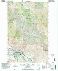
2003 Map of Cashmere
USGS Topo · Published 2006About this map
Cashmere and the small community of Monitor anchor this landscape at the confluence of rugged mountain terrain and the fertile valley of the Wenatchee River. The area's agricultural and industrial infrastructure is clearly visible, featuring the Icicle Canal, a network of flumes, and several Gravel Pits that supported local development. Transportation is defined by the Burlington Northern Santa Fe railroad corridor and the Sunset Highway, which follow the river's path through the foothills. North of the river, the landscape transitions into the protected wilderness of the Swakane State Wildlife Area and Wenatchee National Forest. Here, steep ridges like Tibbetts Mountain and Eagle Rock are carved by numerous drainages, including Nahahum Canyon and Olalla Canyon. This map also marks localized details such as the County Fairground, a Gaging Station, and a local Landing Strip.
Find a feature on this map
45 named features on this map. Tap any name to fly to it.
Don’t see what you’re looking for? This feature index may not catch every label — zoom into the map to look around manually.
Map Details
Editions of this 2003 Cashmere Map
This is the sole edition of this map. No revisions or reprints were ever made.
Other maps of this area

1897 · Mount Stuart
USGS Topo · 1:125,000

1901 · Chelan
USGS Topo · 1:125,000

1901 · Chiwaukum
USGS Topo · 1:125,000

1902 · Mount Stuart
USGS Topo · 1:125,000

1904 · Chiwaukum
USGS Topo · 1:125,000

1913 · Wenatchee
USGS Topo · 1:62,500

1915 · Wenatchee
USGS Topo · 1:62,500

1920 · Colockum Pass
USGS Topo · 1:125,000

1922 · Colockum Pass
USGS Topo · 1:125,000

1957 · Wenatchee
USGS Topo · 1:250,000