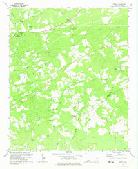
1970 Map of Cassatt
USGS Topo · Published 1975About this map
The settlement of Cassatt serves as the focal point for this survey, situated along the Seaboard Coast Line railroad. The surrounding landscape in this part of South Carolina is defined by a dense network of blackwater drainages and millponds, including Hyatts Millpond, Llewellyn Millpond, and West Millpond. These water features suggest a history of local milling and water management integrated with the agricultural and timbered terrain.
Find a feature on this map
38 named features on this map. Tap any name to fly to it.
Don’t see what you’re looking for? This feature index may not catch every label — zoom into the map to look around manually.
Map Details
Editions of this 1970 Cassatt Map
This is the sole edition of this map. No revisions or reprints were ever made.
Other maps of this area

1935 · Camden
USGS Topo · 1:48,000

1938 · Camden
USGS Topo · 1:62,500

1938 · Hagood
USGS Topo · 1:62,500

1941 · Spartanburg
USGS Topo · 1:250,000

1942 · Camden
USGS Topo · 1:125,000

1953 · Camden South
USGS Topo · 1:24,000

1953 · Spartanburg
USGS Topo · 1:250,000

1957 · Ashwood
USGS Topo · 1:62,500

1960 · Spartanburg
USGS Topo · 1:250,000

1963 · Spartanburg
USGS Topo · 1:250,000