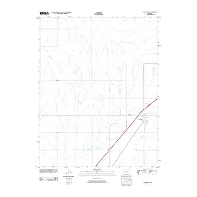
2009 Map of Cassoday
USGS Topo · Published 2009About this map
Cassoday serves as the focal point of this Butler County prairie landscape, where the town grid meets a network of local roads and watercourses. The drainage patterns of the Walnut River and its tributaries, including Middle Creek and School Branch, dictate the layout of the surrounding agricultural land. In the southern portion of the village, the street layout is clearly defined by Main St and S Washington St, providing a detailed look at the community's structural organization at the start of the 21st century. Outside the town limits, the Cassoday Cemetery sits as a quiet landmark along the river’s path. The map also documents the named rural routes such as Ne Satchell Creek Rd and Ne Munson Hill Rd, reflecting the persistent importance of these county roads in connecting the remote Kansas ranching and farming communities.
Find a feature on this map
15 named features on this map. Tap any name to fly to it.
Don’t see what you’re looking for? This feature index may not catch every label — zoom into the map to look around manually.
Map Details
Editions of this 2009 Cassoday Map
This is the sole edition of this map. No revisions or reprints were ever made.
Other maps of this area

1888 · Eldorado
USGS Topo · 1:125,000

1898 · Cottonwood Falls
USGS Topo · 1:125,000

1955 · Wichita
USGS Topo · 1:250,000

1955 · Hutchinson
USGS Topo · 1:250,000

1957 · Wonsevu
USGS Topo · 1:24,000

1958 · Wichita
USGS Topo · 1:250,000

1959 · Hutchinson
USGS Topo · 1:250,000

1961 · De Graff
USGS Topo · 1:24,000

1961 · Rosalia NE
USGS Topo · 1:24,000
1961 · Rosalia NW
USGS Topo · 1:24,000