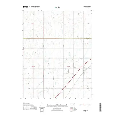
2018 Map of Cassoday
USGS Topo · Published 2018About this map
Cassoday serves as the central hub of this prairie landscape, situated near the intersection of several regional thoroughfares and the winding Walnut River. The topography is defined by the drainage basins of Brush Cr, Middle Cr, and School Br, which carve subtle valleys through the surrounding uplands. Local heritage is centered at the Cassoday Cem and along Main St, while the surrounding rural area is gridded by a network of named roads including Ne Munson Hill Rd and Ne Satchell Creek Rd. This 2018 survey captures the interface between Butler and Chase counties, illustrating the modern rural road system and its relationship to the natural watercourses that have historically shaped the Kansas plains. The map provides a clear view of how township lines like t22s r6e and t23s r7e organize the land into the enduring section-and-range pattern.
Find a feature on this map
30 named features on this map. Tap any name to fly to it.
Don’t see what you’re looking for? This feature index may not catch every label — zoom into the map to look around manually.
Map Details
Editions of this 2018 Cassoday Map
This is the sole edition of this map. No revisions or reprints were ever made.
Other maps of this area

1888 · Eldorado
USGS Topo · 1:125,000

1898 · Cottonwood Falls
USGS Topo · 1:125,000

1955 · Wichita
USGS Topo · 1:250,000

1955 · Hutchinson
USGS Topo · 1:250,000

1957 · Wonsevu
USGS Topo · 1:24,000

1958 · Wichita
USGS Topo · 1:250,000

1959 · Hutchinson
USGS Topo · 1:250,000

1961 · De Graff
USGS Topo · 1:24,000

1961 · Rosalia NE
USGS Topo · 1:24,000
1961 · Rosalia NW
USGS Topo · 1:24,000