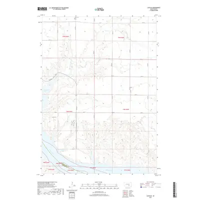
2017 Map of Castalia
USGS Topo · Published 2017About this map
Castalia and the surrounding drainage basins of Charles Mix County meet the northern reaches of the Missouri River in this detailed topographic study. The landscape is defined by the sharp descent of numerous creeks—including Platte Cr, Cedar Cr, and Dry Cr—as they carve southward toward Lake Francis Case. This geography creates a complex series of draws and ridges that contrast with the more regular grid of county roads like 277th St and 359th Ave. Local history is preserved at sites like Castalia Cem and Friesland Cem, which sit atop the higher plateaus. Modern recreation and historical travel intersect where the Lewis and Clark Trl follows the contours near the water's edge, documenting a region where the vast Missouri River reservoir system continues to shape the agricultural and natural environment.
Find a feature on this map
29 named features on this map. Tap any name to fly to it.
Don’t see what you’re looking for? This feature index may not catch every label — zoom into the map to look around manually.
Map Details
Editions of this 2017 Castalia Map
This is the sole edition of this map. No revisions or reprints were ever made.
Other maps of this area

1955 · Mitchell
USGS Topo · 1:250,000

1959 · Mitchell
USGS Topo · 1:250,000

1964 · Campbell Creek
USGS Topo · 1:24,000

1964 · Herrick NE
USGS Topo · 1:24,000

1964 · Whetstone Bay
USGS Topo · 1:24,000

1971 · Academy
USGS Topo · 1:24,000

1971 · Lucas SE
USGS Topo · 1:24,000

1979 · Castalia
USGS Topo · 1:24,000
1979 · Bovee
USGS Topo · 1:24,000

1979 · Lake George
USGS Topo · 1:24,000
Featured Places
- Hamilton Township, SD
- Castalia Township, SD
- Platte Township, SD
- Signal Township, SD
- Charles Mix County, SD