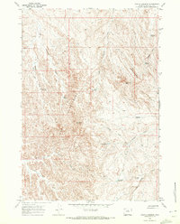
1966 Map of Castle Gardens
USGS Topo · Published 1972About this map
Honeycombs defines the rugged topography of this Washakie County landscape, where wind and water have carved distinct formations into the Wyoming basin. This mid-1960s survey reveals a territory centered on water management and land navigation, evidenced by the numerous small catchments like Witness Corner Reservoir, Chess Reservoir, and Bud Kimball Reservoir. These features, along with a Flowing Well and several labeled Drill Holes, point to the region's reliance on scattered water sources for livestock or resource extraction. Distinctive landmarks such as Castle Gardens, Wild Horse Butte, and Devil North Butte provide natural orientation points across the drainage of Big Cottonwood Creek and Nowater Creek. Movement through this high-desert environment was facilitated by the Blue Bank Road and various unnamed tracks, illustrating how ranchers and surveyors traversed the expansive townships of the Big Horn Basin.
Find a feature on this map
30 named features on this map. Tap any name to fly to it.
Don’t see what you’re looking for? This feature index may not catch every label — zoom into the map to look around manually.
Map Details
Editions of this 1966 Castle Gardens Map
This is the sole edition of this map. No revisions or reprints were ever made.
Other maps of this area

1899 · Cloud peak
USGS Topo · 1:125,000

1901 · Cloud Peak
USGS Topo · 1:125,000

1955 · Sheridan
USGS Topo · 1:250,000

1955 · Arminto
USGS Topo · 1:250,000

1958 · Sheridan
USGS Topo · 1:250,000

1958 · Arminto
USGS Topo · 1:250,000

1962 · Sheridan
USGS Topo · 1:250,000

1962 · Arminto
USGS Topo · 1:250,000

1966 · Deadline Draw
USGS Topo · 1:24,000

1966 · Indian Creek
USGS Topo · 1:24,000