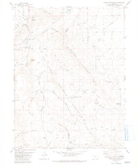
1983 Map of Castle Rock Gulch
USGS Topo · Published 1983About this map
San Isabel National Forest encompasses the high country of Chaffee and Park counties, where mining and ranching legacies intersect with the natural drainages of the Trout Creek basin. The landscape is defined by the prominent Kaufman Ridge and Bassam Ridge, which separate various gulches such as Castle Rock Gulch and Sawmill Gulch. Evidence of early industrial activity is visible in the northwest corner, where an Old RR Grade runs near a lonely Grave and the Trout Creek View No. 2 Mine. Smaller operations like the Lucky Jack Mine and numerous Prospects are scattered throughout the drainages. On the eastern side, the terrain softens into the Dry Lakes area, featuring ranching landmarks such as the Green Whiskers Windmill, providing a clear record of the multiple uses of this public land in the early 1980s.
Find a feature on this map
38 named features on this map. Tap any name to fly to it.
Don’t see what you’re looking for? This feature index may not catch every label — zoom into the map to look around manually.
Map Details
Editions of this 1983 Castle Rock Gulch Map
2 editions found
Other maps of this area

1954 · Pueblo
USGS Topo · 1:250,000

1955 · Buena Vista
USGS Topo · 1:62,500

1956 · Antero Reservoir
USGS Topo · 1:24,000

1956 · Antero Reservoir NE
USGS Topo · 1:24,000

1956 · Cameron Mountain
USGS Topo · 1:62,500

1956 · Poncha Springs
USGS Topo · 1:62,500

1956 · Montrose
USGS Topo · 1:250,000

1957 · Pueblo
USGS Topo · 1:250,000

1958 · Pueblo
USGS Topo · 1:250,000

1959 · Montrose
USGS Topo · 1:250,000