1972 Map of Castle Rock NE
USGS Topo · Published 1974About this map
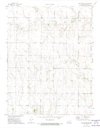
Collyer township's western edge in Trego County is defined by a series of deep drainage patterns carving through the Kansas plains. The landscape is primarily shaped by the meandering course of Big Creek, which enters from the west and winds across the northern sections, while Downer Creek cuts through the southeastern corner of the quadrangle. Human presence in this rural environment is anchored by Banner Ch, situated in the southern reach, and occasional industrial activity represented by a Gravel Pit. Numerous wells are scattered across the terrain, reflecting the area's reliance on underground resources in an era of established agricultural and ranching homesteads. The intricate contour work illustrates the gradual descent toward the creek beds, showing how water has historically dictated the movement and settlement patterns of this central Kansas region.
Find a feature on this map
7 named features on this map. Tap any name to fly to it.
Don’t see what you’re looking for? This feature index may not catch every label — zoom into the map to look around manually.
Map Details
Editions of this 1972 Castle Rock NE Map
This is the sole edition of this map. No revisions or reprints were ever made.
Other maps of this area

1893 · Ellis
USGS Topo · 1:125,000

1893 · Hill
USGS Topo · 1:125,000

1954 · Goodland
USGS Topo · 1:250,000

1955 · Great Bend
USGS Topo · 1:250,000

1955 · Scott City
USGS Topo · 1:250,000

1955 · Beloit
USGS Topo · 1:250,000

1956 · Goodland
USGS Topo · 1:250,000

1957 · Goodland
USGS Topo · 1:250,000

1957 · Great Bend
USGS Topo · 1:250,000

1958 · Great Bend
USGS Topo · 1:250,000