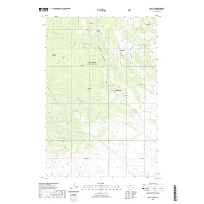
2020 Map of Castle Town
USGS Topo · Published 2020About this map
Lewis & Clark National Forest encompasses the high country of the Castle Mountains in this modern survey of Meagher County. The terrain is defined by prominent elevations like Wapiti Peak and Elk Peak, which overlook a network of creek drainages including Warm Springs Cr and Alabaugh Cr. The map centers on the historical site of Castle Town, where the Castle Cem remains a quiet landmark of the area's pioneer past. Nearby, the settlement of Robinson is situated among several ridges and old road connections such as the Lucky Dollar and Bergs Jeep. Local water features, notably Alabaugh-Castle Lake and Castle Lake, suggest a landscape shaped by both alpine hydrology and historical land use. The presence of Yankee Jim Ridge and Hamilton Ridge further illustrates the complex topography of this high-elevation Montana environment.
Find a feature on this map
47 named features on this map. Tap any name to fly to it.
Don’t see what you’re looking for? This feature index may not catch every label — zoom into the map to look around manually.
Map Details
Editions of this 2020 Castle Town Map
This is the sole edition of this map. No revisions or reprints were ever made.
Other maps of this area

1886 · Little Belt Mts.
USGS Topo · 1:250,000

1894 · Little Belt Mts.
USGS Topo · 1:250,000

1897 · Little Belt Mts.
USGS Topo · 1:250,000

1898 · Little Belt Mts.
USGS Topo · 1:250,000

1902 · Little Belt Mts.
USGS Topo · 1:250,000

1948 · White Sulphur Springs
USGS Topo · 1:250,000

1951 · Hamen
USGS Topo · 1:24,000
1951 · Ringling
USGS Topo · 1:24,000

1951 · Rimrock Divide
USGS Topo · 1:24,000

1958 · White Sulphur Springs
USGS Topo · 1:250,000