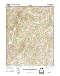
2013 Map of Castleton
USGS Topo · Published 2013About this map
Griffinsburg and its surrounding hamlets occupy a landscape defined by the branching tributaries of the Hazel River and the Thornton River. The 2013 topography reveals a network of small residential clusters and agricultural holdings, such as Monumental Mills in the east and Eggbornsville at a central crossroads. The terrain is marked by prominent peaks including Castleton Mountain and Scott Mountain, which overlook the dispersed settlements. Modern developments like the Village at Griffinsburg and West Lakes appear alongside older place names, showing the continued evolution of Culpeper County. Local researchers can trace the reach of Muddy Run and Devils Run as they weave between high points like Drogheda Mountain and Davis Mountain, illustrating the deep connection between the region's hydrology and its settlement patterns.
Find a feature on this map
141 named features on this map. Tap any name to fly to it.
Don’t see what you’re looking for? This feature index may not catch every label — zoom into the map to look around manually.
Map Details
Editions of this 2013 Castleton Map
This is the sole edition of this map. No revisions or reprints were ever made.
Other maps of this area

1887 · Spottsylvania
USGS Topo · 1:125,000

1892 · Spottsylvania
USGS Topo · 1:125,000

1892 · Gordonsville
USGS Topo · 1:125,000

1893 · Luray
USGS Topo · 1:125,000

1894 · Warrenton
USGS Topo · 1:125,000

1894 · Warrenton
USGS Topo · 1:62,500

1905 · Luray
USGS Topo · 1:125,000

1927 · Remington
USGS Topo · 1:48,000

1930 · Warrenton
USGS Topo · 1:62,500

1943 · Culpeper
USGS Topo · 1:24,000