1999 Map of Catasauqua
USGS Topo · Published 2001About this map
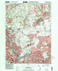
The industrial corridor along the Lehigh River anchors this 1999 survey, showing the late-century convergence of the Allentown, Bethlehem, and Catasauqua urban areas. The landscape reveals a complex network of transportation and commerce, from the legacy rail lines of the Lehigh Valley RR and the Central RR of New Jersey to the modern sprawl of the Lehigh Valley Shopping Mall. Residential development has filled much of the space between historic cores like Fullerton and North Catasauqua, though hills like Sauerkraut Hill and agricultural remnants near Dannersville persist at the northern edges.
Find a feature on this map
96 named features on this map. Tap any name to fly to it.
Don’t see what you’re looking for? This feature index may not catch every label — zoom into the map to look around manually.
Map Details
Editions of this 1999 Catasauqua Map
This is the sole edition of this map. No revisions or reprints were ever made.
Other maps of this area

1894 · Allentown
USGS Topo · 1:62,500

1902 · Slatington
USGS Topo · 1:62,500

1914 · Wind Gap
USGS Topo · 1:62,500

1916 · Wind Gap
USGS Topo · 1:62,500

1922 · Mauch Chunk
USGS Topo · 1:62,500

1924 · Mauch Chunk
USGS Topo · 1:62,500

1937 · Allentown West
USGS Topo · 1:48,000

1939 · Allentown
USGS Topo · 1:62,500

1942 · Allentown West
USGS Topo · 1:62,500

1943 · Mauch Chunk
USGS Topo · 1:62,500