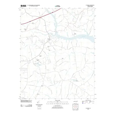
2010 Map of Catawba
USGS Topo · Published 2010About this map
Bunker Hill Covered Bridge stands as a landmark of nineteenth-century engineering, spanning Lyle Creek in this western Piedmont landscape. The town of Catawba serves as a central hub, while the surrounding countryside is defined by the winding course of the Catawba River and its impoundment at Lake Norman. Local history is preserved in small family and community burial grounds, such as Smyres Cemetery and Providence Memorial Cemetery, and through the legacy of early industry found at Murrays Mill Lake and its associated Murrays Mill Pond Dam. The terrain is etched with numerous watercourses, including Balls Creek and McLin Creek, which shaped the placement of rural settlements like Bandy and Buffalo. Historic transportation routes like Stagecoach Rd and Old Beatty's Ford Rd connect these points, reflecting centuries of travel through the region.
Find a feature on this map
73 named features on this map. Tap any name to fly to it.
Don’t see what you’re looking for? This feature index may not catch every label — zoom into the map to look around manually.
Map Details
Editions of this 2010 Catawba Map
This is the sole edition of this map. No revisions or reprints were ever made.
Other maps of this area

1893 · Statesville
USGS Topo · 1:125,000

1895 · Hickory
USGS Topo · 1:125,000

1953 · Charlotte
USGS Topo · 1:250,000

1954 · Charlotte
USGS Topo · 1:250,000

1960 · Charlotte
USGS Topo · 1:250,000

1962 · Charlotte
USGS Topo · 1:250,000

1969 · Troutman
USGS Topo · 1:24,000

1969 · Statesville West
USGS Topo · 1:24,000
1970 · Maiden
USGS Topo · 1:24,000
1970 · Lake Norman North
USGS Topo · 1:24,000