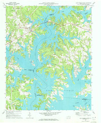
1970 Map of Lake Norman North
USGS Topo · Published 1972About this map
Lake Norman dominates the landscape following the impoundment of the Catawba River, creating a complex shoreline of deep coves and peninsulas across Iredell, Catawba, and Lincoln counties. This 1970 survey shows the area during a period of transition as the newly formed reservoir began to reshape local geography. Traditional rural settlements like Sherrills Ford, Terrell, and Mayhew remain connected by the Southern and Seaboard railroads, while new lakeside developments like Westport begin to emerge. Local history is anchored by several community landmarks, including Motto Grove Church, Rehobeth Church, and Webbs Chapel. The presence of Gold Mine Island and the Mooresville Airport near Doolie further distinguish the northern reaches of the lake. The map also records the persistence of older place names like Gold Mine Island and the creek systems of Stumpy Creek and McCrary Creek that now feed the reservoir.
Find a feature on this map
42 named features on this map. Tap any name to fly to it.
Don’t see what you’re looking for? This feature index may not catch every label — zoom into the map to look around manually.
Map Details
Editions of this 1970 Lake Norman North Map
3 editions found
Other maps of this area

1893 · Statesville
USGS Topo · 1:125,000

1895 · Hickory
USGS Topo · 1:125,000

1914 · Gastonia
USGS Topo · 1:48,000

1916 · Gastonia
USGS Topo · 1:62,500

1941 · Charlotte
USGS Topo · 1:125,000

1942 · Charlotte
USGS Topo · 1:125,000

1949 · Hicks Crossroads
USGS Topo · 1:24,000

1953 · Charlotte
USGS Topo · 1:250,000

1954 · Charlotte
USGS Topo · 1:250,000

1960 · Charlotte
USGS Topo · 1:250,000