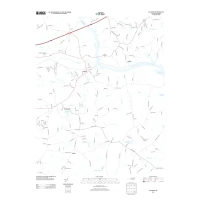
2013 Map of Catawba
USGS Topo · Published 2013About this map
The Catawba River winds through the heart of this region, shaping the landscape near the town of Catawba and the community of Buffalo. To the northwest, the Bunker Hill Covered Bridge stands as a significant landmark near Lyle Cr, representing the area's early transportation history. The terrain is marked by multiple watercourses, including Balls Cr and Gold Mine Cr, which feed into the larger river system and the expansive Lake Norman on the eastern edge.
Find a feature on this map
181 named features on this map. Tap any name to fly to it.
Don’t see what you’re looking for? This feature index may not catch every label — zoom into the map to look around manually.
Map Details
Editions of this 2013 Catawba Map
This is the sole edition of this map. No revisions or reprints were ever made.
Other maps of this area

1893 · Statesville
USGS Topo · 1:125,000

1895 · Hickory
USGS Topo · 1:125,000

1953 · Charlotte
USGS Topo · 1:250,000

1954 · Charlotte
USGS Topo · 1:250,000

1960 · Charlotte
USGS Topo · 1:250,000

1962 · Charlotte
USGS Topo · 1:250,000

1969 · Troutman
USGS Topo · 1:24,000

1969 · Statesville West
USGS Topo · 1:24,000
1970 · Maiden
USGS Topo · 1:24,000
1970 · Lake Norman North
USGS Topo · 1:24,000