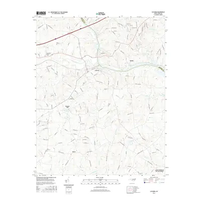
2016 Map of Catawba
USGS Topo · Published 2016About this map
Catawba and the surrounding Catawba County countryside are defined by a complex network of creeks and modern reservoirs where the Piedmont terrain meets the water. The historic Bunker Hill Covered Bridge stands as a significant landmark near Lyle Creek, while further south, the landscape rises toward Murrays Hill and Murrays Mill Lake. This mid-2010s survey captures the area after the mid-century creation of Lake Norman, which altered the original flow of the Catawba River and its many tributaries like Balls Cr and Broad Meadow Cr. Smaller settlements such as Buffalo and Bandy anchor the rural crossroads, while several local burying grounds, including Smyres Cem and Providence Memorial Cem, provide essential data points for those researching family history in the region. The map also details more recent developments such as Comm Scope Lake and the residential area of Lake Norman of Catawba.
Find a feature on this map
132 named features on this map. Tap any name to fly to it.
Don’t see what you’re looking for? This feature index may not catch every label — zoom into the map to look around manually.
Map Details
Editions of this 2016 Catawba Map
This is the sole edition of this map. No revisions or reprints were ever made.
Other maps of this area

1893 · Statesville
USGS Topo · 1:125,000

1895 · Hickory
USGS Topo · 1:125,000

1953 · Charlotte
USGS Topo · 1:250,000

1954 · Charlotte
USGS Topo · 1:250,000

1960 · Charlotte
USGS Topo · 1:250,000

1962 · Charlotte
USGS Topo · 1:250,000

1969 · Troutman
USGS Topo · 1:24,000

1969 · Statesville West
USGS Topo · 1:24,000
1970 · Maiden
USGS Topo · 1:24,000
1970 · Lake Norman North
USGS Topo · 1:24,000