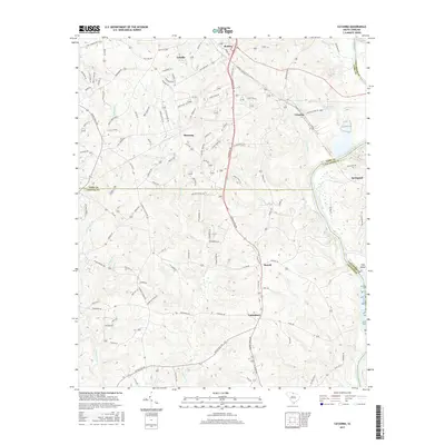
2017 Map of Catawba
USGS Topo · Published 2017About this map
Catawba River serves as the prominent physical and political boundary on this map, separating York, Lancaster, and Chester counties. Along its banks and the neighboring uplands, small communities like Harmony, Catawba, and Landsford anchor a landscape defined by creeks and family-named roads. The terrain is marked by significant water features, including Burkette Lake near Lesslie and the broad flow around Culp Island.
Find a feature on this map
120 named features on this map. Tap any name to fly to it.
Don’t see what you’re looking for? This feature index may not catch every label — zoom into the map to look around manually.
Map Details
Editions of this 2017 Catawba Map
This is the sole edition of this map. No revisions or reprints were ever made.
Other maps of this area

1941 · Spartanburg
USGS Topo · 1:250,000

1949 · Rock Hill
USGS Topo · 1:62,500

1953 · Spartanburg
USGS Topo · 1:250,000

1960 · Spartanburg
USGS Topo · 1:250,000

1963 · Spartanburg
USGS Topo · 1:250,000

1964 · Spartanburg
USGS Topo · 1:250,000

1968 · Van Wyck
USGS Topo · 1:24,000

1968 · Catawba
USGS Topo · 1:24,000
1968 · Catawba NE
USGS Topo · 1:24,000
1968 · Rock Hill East
USGS Topo · 1:24,000