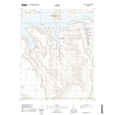
2020 Map of Cathedral Canyon
USGS Topo · Published 2020About this map
Glen Canyon National Recreation Area dominates the northern reaches of this map, where the waters of Lake Powell intersect with the dramatic topography of the Utah-Arizona border. The landscape is a complex network of drainage systems, including Wetherill Canyon, Mountain Sheep Canyon, and the eponymous Cathedral Canyon. These deep incisions in the earth are surrounded by high-elevation features such as Rainbow Plateau and Cummings Mesa. Local landmarks with distinct character include Teddys Horse Pasture and Cathedral Butte. Geologic points of interest like Keyhole Arch and Carrot Top Arch are documented alongside the shifting shoreline of the reservoir. This map effectively illustrates the transition from the high mesas of Coconino County into the flooded canyons of the Colorado River system, showing the state and county lines as they cross through this water-carved terrain.
Find a feature on this map
22 named features on this map. Tap any name to fly to it.
Don’t see what you’re looking for? This feature index may not catch every label — zoom into the map to look around manually.
Map Details
Editions of this 2020 Cathedral Canyon Map
This is the sole edition of this map. No revisions or reprints were ever made.
Other maps of this area

1883 · Marsh Pass
USGS Topo · 1:250,000

1886 · Escalante
USGS Topo · 1:250,000

1886 · Henry Mountains
USGS Topo · 1:250,000

1886 · Echo Cliffs
USGS Topo · 1:250,000

1891 · Echo Cliffs
USGS Topo · 1:250,000

1892 · Marsh Pass
USGS Topo · 1:250,000

1892 · Henry Mountains
USGS Topo · 1:250,000

1953 · Cummings Mesa
USGS Topo · 1:62,500

1953 · Navajo Mountain
USGS Topo · 1:62,500

1954 · Navajo Creek
USGS Topo · 1:62,500