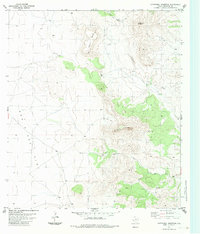
1983 Map of Cathedral Mountain
USGS Topo · Published 1983About this map
Cathedral Mountain dominates this portion of the Texas landscape, serving as a primary vertical landmark amidst the high desert terrain. This 1983 edition, based on earlier photogrammetric data, reveals a high-altitude ranching environment defined by wide open spaces like One One Flat and the prominent Terry Mesa. The scarcity of water is evident through the naming of seasonal features such as Deer Lick Draw and the more reliable Calamity Creek, alongside human-engineered water sources like Tank and Terry Well.
Find a feature on this map
12 named features on this map. Tap any name to fly to it.
Don’t see what you’re looking for? This feature index may not catch every label — zoom into the map to look around manually.
Map Details
Editions of this 1983 Cathedral Mountain Map
This is the sole edition of this map. No revisions or reprints were ever made.
Other maps of this area

1895 · Alpine
USGS Topo · 1:125,000

1954 · Fort Stockton
USGS Topo · 1:250,000

1958 · Fort Stockton
USGS Topo · 1:250,000

1972 · Bird Mountain
USGS Topo · 1:24,000

1972 · Paisano
USGS Topo · 1:24,000

1972 · Alpine South
USGS Topo · 1:24,000

1973 · Fort Stockton
USGS Topo · 1:250,000
1983 · Mount Ord
USGS Topo · 1:24,000
1983 · Cactus Flat
USGS Topo · 1:24,000
1983 · Goat Mountain
USGS Topo · 1:24,000