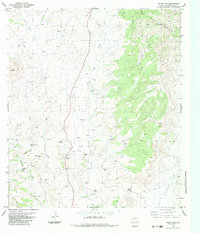
1983 Map of Mount Ord
USGS Topo · Published 1983About this map
The Del Norte Mountains dominate this high-desert landscape in Brewster County, where the topography transitions from the dramatic Mount Ord Basin to the flat expanse of Chalk Valley. Water is the defining resource of this arid region, as evidenced by the dense cluster of named water sources like L-H Springs, Clark Springs, and Nine Troughs Spring. These springs likely served as critical waypoints for local ranching operations and travelers through the corridor between Haley Mountain and Eagle Peak. Resource extraction and navigation are highlighted by features such as Opal Mine Hill and the Radio Tower Mount Ord, which marks the highest elevation point on the sheet. The network of unnamed tracks and a prominent Jeep Trail suggest a landscape managed for cattle and sparse rural infrastructure during the early 1980s.
Find a feature on this map
26 named features on this map. Tap any name to fly to it.
Don’t see what you’re looking for? This feature index may not catch every label — zoom into the map to look around manually.
Map Details
Editions of this 1983 Mount Ord Map
This is the sole edition of this map. No revisions or reprints were ever made.
Other maps of this area

1895 · Alpine
USGS Topo · 1:125,000

1920 · Monument Spring
USGS Topo · 1:62,500

1921 · Monument Spring
USGS Topo · 1:62,500

1923 · Altuda
USGS Topo · 1:62,500

1954 · Fort Stockton
USGS Topo · 1:250,000

1958 · Fort Stockton
USGS Topo · 1:250,000

1972 · Bird Mountain
USGS Topo · 1:24,000

1972 · Alpine South
USGS Topo · 1:24,000

1973 · Fort Stockton
USGS Topo · 1:250,000
1983 · Goat Mountain
USGS Topo · 1:24,000