
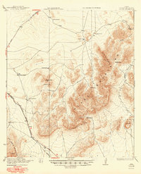
1923 Map of Altuda
USGS Topo · Published 1923About this map
Altuda sits at the southwestern edge of the Glass Mountains, serving as a vital point on the Southern Pacific System railroad during the early 1920s. This survey, conducted in cooperation with the War Department, reveals a landscape defined by isolated homesteads and high-elevation landmarks. To the east, the terrain rises toward the prominent heights of Old Blue Mtn and Cathedral Mtn, while the Bissett Mine indicates the era's mineral prospecting near Bissett Mtn. The map documents numerous family-named landmarks including the Stroud Ranch, Esterwood Ranch, and the Beaty Place, which are connected by early roads leading toward Fort Stockton and Alpine. The presence of Ainsleys Cabin and several springs like those in Gilliland Canyon highlights the essential water sources required for ranching and settlement in this arid Texas environment.
Find a feature on this map
26 named features on this map. Tap any name to fly to it.
Don’t see what you’re looking for? This feature index may not catch every label — zoom into the map to look around manually.
Map Details
Editions of this 1923 Altuda Map
2 editions found
Other maps of this area

1894 · Fort Davis
USGS Topo · 1:125,000

1895 · Alpine
USGS Topo · 1:125,000

1897 · Fort Davis
USGS Topo · 1:125,000

1920 · Monument Spring
USGS Topo · 1:62,500

1920 · Marathon
USGS Topo · 1:62,500

1921 · Monument Spring
USGS Topo · 1:62,500

1921 · Marathon
USGS Topo · 1:62,500

1923 · Hess Canyon
USGS Topo · 1:62,500

1929 · Hovey
USGS Topo · 1:125,000

1954 · Fort Stockton
USGS Topo · 1:250,000