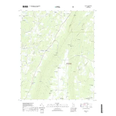
2020 Map of Catlett
USGS Topo · Published 2020About this map
Taylor Ridge dominates the central landscape of this Walker County region, dividing the drainage basins of Chickamauga Creek and W Armuchee Cr. The settlement patterns follow the narrow valleys and gaps, with the community of Naomi situated at a key crossroads near Naomi Cem. To the south, the terrain descends into Milan Hollow and Walden Hollow, eventually reaching Suttles Mill and East Armuchee near the southern boundary.
Find a feature on this map
111 named features on this map. Tap any name to fly to it.
Don’t see what you’re looking for? This feature index may not catch every label — zoom into the map to look around manually.
Map Details
Editions of this 2020 Catlett Map
This is the sole edition of this map. No revisions or reprints were ever made.
Other maps of this area

1886 · Ringgold
USGS Topo · 1:125,000

1892 · Ringgold
USGS Topo · 1:125,000

1935 · Catlett
USGS Topo · 1:24,000

1935 · Villanow
USGS Topo · 1:24,000

1935 · Nickajack Gap
USGS Topo · 1:24,000

1935 · Tunnel Hill
USGS Topo · 1:24,000

1936 · Kensington
USGS Topo · 1:24,000

1936 · Estelle
USGS Topo · 1:24,000
1943 · Tunnel Hill
USGS Topo · 1:24,000

1946 · Kensington
USGS Topo · 1:24,000