
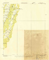
1935 Map of Tunnel Hill
USGS Topo · Published 1935About this map
Chetoogeta Mountain Tunnel serves as the centerpiece of this 1935 landscape, where the engineering of the St Louis and San Francisco RR pierces the barrier of Tunnel Hill Ridge. The map documents a rural network of ridges and valleys defined by small agrarian communities and crossroads such as Tunnel Hill and Trickum. The Tennessee Valley Authority, under chairman Arthur E. Morgan, provides an intricate view of early 20th-century Georgia before the widespread consolidation of local institutions. Dozens of small landmarks are visible, from the Airway Beacon on Rocky Face Mountain to family-linked sites like Foster Cem and rural spiritual hubs including Mt Salem Ch and Dunnidin Ch. The proximity of the Nashville and Chattanooga Highway highlights the era's emerging automobile infrastructure alongside long-established features like Mill Creek Gap.
Find a feature on this map
59 named features on this map. Tap any name to fly to it.
Don’t see what you’re looking for? This feature index may not catch every label — zoom into the map to look around manually.
Map Details
Editions of this 1935 Tunnel Hill Map
This is the sole edition of this map. No revisions or reprints were ever made.
Other maps of this area

1886 · Dalton
USGS Topo · 1:125,000

1886 · Ringgold
USGS Topo · 1:125,000

1892 · Ringgold
USGS Topo · 1:125,000

1892 · Dalton
USGS Topo · 1:125,000

1897 · Dalton
USGS Topo · 1:125,000

1935 · Catlett
USGS Topo · 1:24,000

1935 · East Ridge
USGS Topo · 1:24,000
1935 · Tiger Creek
USGS Topo · 1:24,000

1935 · Villanow
USGS Topo · 1:24,000

1935 · Ringgold
USGS Topo · 1:24,000