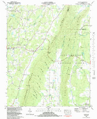
1982 Map of Catlett
USGS Topo · Published 1983About this map
Taylor Ridge and Dick Ridge define the vertical grain of this landscape, carving out the narrow Armuchee Valley where rural life centered in the early 1980s. The map documents a landscape of small upland farms and clustered communities like Catlett and Naomi, connected by a network of hollows including Walden Hollow and Milan Hollow. Social life is anchored by numerous small country churches such as Prospect Ch and Lake Howard Ch, alongside several family cemeteries like Whitley Cem and Goodram Cem that reflect generations of settlement along the eastern flank of the Tennessee Valley Divide. The eastern half is dominated by the Chattahoochee National Forest, where the terrain rises sharply toward Hampton Mountain and the Lookout Scenic Highway follows the ridgeline.
Find a feature on this map
70 named features on this map. Tap any name to fly to it.
Don’t see what you’re looking for? This feature index may not catch every label — zoom into the map to look around manually.
Map Details
Editions of this 1982 Catlett Map
This is the sole edition of this map. No revisions or reprints were ever made.
Other maps of this area

1886 · Ringgold
USGS Topo · 1:125,000

1892 · Ringgold
USGS Topo · 1:125,000

1935 · Catlett
USGS Topo · 1:24,000

1935 · Villanow
USGS Topo · 1:24,000

1935 · Nickajack Gap
USGS Topo · 1:24,000

1935 · Tunnel Hill
USGS Topo · 1:24,000

1936 · Kensington
USGS Topo · 1:24,000

1936 · Estelle
USGS Topo · 1:24,000
1943 · Tunnel Hill
USGS Topo · 1:24,000

1946 · Kensington
USGS Topo · 1:24,000