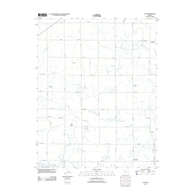
2012 Map of Cato
USGS Topo · Published 2012About this map
Cato and the surrounding Crawford County countryside are defined by a dense concentration of rural burial grounds and a grid of secondary roads in the early 21st century. The map reveals a high density of small family or community cemeteries, including Pine Lawn Cem, Tweedy Cem, and Howard Cem, which offer significant value for genealogical research in this part of Kansas. The landscape is drained by a network of waterways such as Buck Run and W Fork Dry Wood Cr, which meander through a region primarily settled around small hubs like Garland and Dry Wood. In the southwest corner, the Bone Creek Reservoir stands as a primary water feature, while the presence of landmarks like Old Arcadia Cem near the eastern border provides a spatial link to the neighboring community of Arcadia.
Find a feature on this map
39 named features on this map. Tap any name to fly to it.
Don’t see what you’re looking for? This feature index may not catch every label — zoom into the map to look around manually.
Map Details
Editions of this 2012 Cato Map
This is the sole edition of this map. No revisions or reprints were ever made.
Other maps of this area

1884 · Fort Scott
USGS Topo · 1:125,000

1886 · Fort Scott
USGS Topo · 1:125,000

1893 · Fort Scott
USGS Topo · 1:125,000

1939 · Deerfield
USGS Topo · 1:24,000

1942 · Deerfield
USGS Topo · 1:24,000

1947 · Joplin
USGS Topo · 1:250,000

1948 · Mulberry
USGS Topo · 1:62,500
1948 · Liberal
USGS Topo · 1:24,000

1948 · Girard
USGS Topo · 1:62,500
1948 · Garland
USGS Topo · 1:24,000