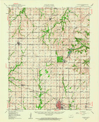
1948 Map of Girard
USGS Topo · Published 1963About this map
The town of Girard anchors the southern portion of this landscape, a region defined by the convergence of the Missouri Kansas and Texas, St Louis San Francisco, and Atchison Topeka and Santa Fe railroads. These lines transported the agricultural and industrial output of Bourbon and Crawford counties during the mid-20th century. To the north, Farlington Lake and the adjacent Fish Hatchery within the State Park provide a distinct contrast to the surrounding grid of section-line roads.
Find a feature on this map
58 named features on this map. Tap any name to fly to it.
Don’t see what you’re looking for? This feature index may not catch every label — zoom into the map to look around manually.
Map Details
Editions of this 1948 Girard Map
This is the sole edition of this map. No revisions or reprints were ever made.
Other maps of this area

1884 · Fort Scott
USGS Topo · 1:125,000

1886 · Joplin
USGS Topo · 1:125,000

1886 · Iola
USGS Topo · 1:125,000

1886 · Fort Scott
USGS Topo · 1:125,000

1886 · Parsons
USGS Topo · 1:125,000

1893 · Fort Scott
USGS Topo · 1:125,000
1893 · Iola
USGS Topo · 1:125,000

1893 · Parsons
USGS Topo · 1:125,000

1894 · Joplin
USGS Topo · 1:125,000

1904 · Iola
USGS Topo · 1:125,000