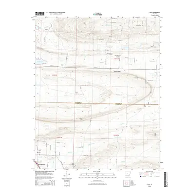
2014 Map of Cato
USGS Topo · Published 2014About this map
White Oak Bayou and the headwaters of Bayou Meto define the hydrology of this central Arkansas landscape, where the ridge-and-valley terrain of the Ouachita foothills meets the expanding outskirts of the Little Rock metropolitan area. The map highlights a series of distinctive heights, from Wilson Hill in the north to Flat Rock Mtn and Clifton Mtn further south. Settlement patterns follow the topography, with established crossroads such as Brockington Corner and Gentry Corner situated along the primary transit corridors. Genealogists will find notable burial sites including Mt Psyam Cem and Cato Cem near the historic community of Cato. The southern edge of the survey captures the northern expansion of Maumelle and Morgan, showing the transition from rural timber and creek bottoms to residential development near Lake Conway.
Find a feature on this map
95 named features on this map. Tap any name to fly to it.
Don’t see what you’re looking for? This feature index may not catch every label — zoom into the map to look around manually.
Map Details
Editions of this 2014 Cato Map
This is the sole edition of this map. No revisions or reprints were ever made.
Other maps of this area

1891 · Little Rock
USGS Topo · 1:125,000

1893 · Little Rock
USGS Topo · 1:125,000

1935 · Mc Almont
USGS Topo · 1:24,000

1935 · North Little Rock
USGS Topo · 1:24,000

1941 · Olmstead
USGS Topo · 1:31,680

1943 · Pinnacle Mtn
USGS Topo · 1:31,680

1953 · Cato
USGS Topo · 1:24,000

1953 · Mayflower
USGS Topo · 1:24,000
1954 · Pinnacle Mountain
USGS Topo · 1:24,000

1954 · Mc Almont
USGS Topo · 1:24,000