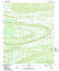
1987 Map of Cato
USGS Topo · Published 1987About this map
Camp Joseph T Robinson dominates the central landscape of this survey, defining a transition between the northern reaches of Pulaski County and the Faulkner County line. The map illustrates a period when military reservation boundaries coincided with a mix of rural settlements and emerging residential patterns. To the south, the community of Morgan and the Immaculate Heart of Mary School represent established local centers, while small crossroads like Brockington Corner and Gentry Corner mark older navigation points. The varied terrain is shaped by Clifton Mountain and the Rock Ridge, with several drainages like White Oak Bayou and Kellogg Creek carving through the hills. This document is particularly valuable for tracing local genealogy and land use, documenting numerous small landmarks including the Mt Psyam Cemetery and Cedar Heights Church.
Find a feature on this map
53 named features on this map. Tap any name to fly to it.
Don’t see what you’re looking for? This feature index may not catch every label — zoom into the map to look around manually.
Map Details
Editions of this 1987 Cato Map
This is the sole edition of this map. No revisions or reprints were ever made.
Other maps of this area

1891 · Little Rock
USGS Topo · 1:125,000

1893 · Little Rock
USGS Topo · 1:125,000

1935 · Mc Almont
USGS Topo · 1:24,000

1935 · North Little Rock
USGS Topo · 1:24,000

1941 · Olmstead
USGS Topo · 1:31,680

1943 · Pinnacle Mtn
USGS Topo · 1:31,680

1953 · Cato
USGS Topo · 1:24,000

1953 · Mayflower
USGS Topo · 1:24,000
1954 · Pinnacle Mountain
USGS Topo · 1:24,000

1954 · Mc Almont
USGS Topo · 1:24,000