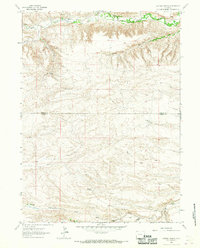
1963 Map of Cattail Ranch
USGS Topo · Published 1967About this map
Bear Creek and Horse Creek dominate this high plains landscape along the Goshen Co and Laramie Co line in the early 1960s. The map documents a classic Western ranching economy, where water management is central to the viability of the land, illustrated by the presence of the Durbin Ditch and numerous springs. Isolated family-named properties like the Griffin Homestead and Weaver Homestead point to the area's early settlement history, while the L Kirkbride Ranch and D Kirkbride Ranch show established operations during the mid-century period. Other distinct residential sites, labeled as the Wilkinson Place and Robinson Place, offer specific data points for genealogists tracing family footprints across these drainages, including the aptly named Cattail Creek and the southern Bullwacker Draw.
Find a feature on this map
17 named features on this map. Tap any name to fly to it.
Don’t see what you’re looking for? This feature index may not catch every label — zoom into the map to look around manually.
Map Details
Editions of this 1963 Cattail Ranch Map
This is the sole edition of this map. No revisions or reprints were ever made.
Other maps of this area

1899 · Goshen Hole
USGS Topo · 1:125,000

1911 · Cheyenne
USGS Topo · 1:125,000

1914 · Cheyenne
USGS Topo · 1:125,000

1954 · Cheyenne
USGS Topo · 1:250,000

1958 · Cheyenne
USGS Topo · 1:250,000

1960 · Diamond Flat
USGS Topo · 1:24,000

1960 · Rocky Hollow
USGS Topo · 1:24,000

1963 · Little Indian Draw
USGS Topo · 1:24,000

1963 · Midway
USGS Topo · 1:24,000

1963 · C S Ranch
USGS Topo · 1:24,000