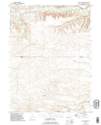
1990 Map of Cattail Ranch
USGS Topo · Published 1995About this map
Weaver Homestead and several family-named ranching sites define this high-plains landscape along the border of Goshen and Laramie counties. The area is characterized by a series of parallel watercourses including Bear Creek, Little Bear Creek, and Cattail Creek, which flow through the dissected terrain towards the east. The map provides a detailed view of the 20th-century ranching infrastructure, capturing the locations of the L Kirkbride Ranch, D Kirkbride Ranch, and the Wilkinson Place. These labels, alongside the Cattail Ranch and Robinson Place, reflect a settlement pattern of widely spaced, autonomous agricultural units. The northern portion of the map is dominated by the steep breaks of the Bear Creek valley, while the southern section shows the more gradual descent into Bulberhacker Draw and the Horse Creek drainage, illustrating the complex hydrology of this corner of Wyoming.
Find a feature on this map
16 named features on this map. Tap any name to fly to it.
Don’t see what you’re looking for? This feature index may not catch every label — zoom into the map to look around manually.
Map Details
Editions of this 1990 Cattail Ranch Map
This is the sole edition of this map. No revisions or reprints were ever made.
Other maps of this area

1899 · Goshen Hole
USGS Topo · 1:125,000

1911 · Cheyenne
USGS Topo · 1:125,000

1914 · Cheyenne
USGS Topo · 1:125,000

1954 · Cheyenne
USGS Topo · 1:250,000

1958 · Cheyenne
USGS Topo · 1:250,000

1960 · Diamond Flat
USGS Topo · 1:24,000

1960 · Rocky Hollow
USGS Topo · 1:24,000

1963 · Little Indian Draw
USGS Topo · 1:24,000

1963 · Midway
USGS Topo · 1:24,000

1963 · C S Ranch
USGS Topo · 1:24,000