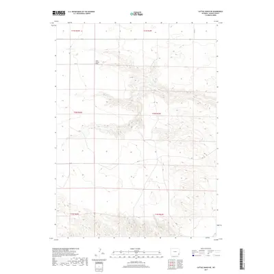
2017 Map of Cattail Ranch NE
USGS Topo · Published 2017About this map
Iowa Center Flats occupies the northern expanse of this Goshen County landscape, where the plateau gives way to the drainage systems of the High Plains. This 2017 survey shows a region defined by its wide, open topography and a network of rural roads that follow the section lines of the Public Land Survey System. The intermittent flow of Fox Cr meanders across the central portion of the quadrangle, carving subtle drainages into the terrain as it moves through township T20N. The area is characterized by large-scale agricultural or ranching divisions, evidenced by the prominent labeling of road segments like Rd 9 and Rd 24. This map offers a clear view of the modern land management and hydrological patterns in this corner of Wyoming.
Find a feature on this map
14 named features on this map. Tap any name to fly to it.
Don’t see what you’re looking for? This feature index may not catch every label — zoom into the map to look around manually.
Map Details
Editions of this 2017 Cattail Ranch NE Map
This is the sole edition of this map. No revisions or reprints were ever made.
Other maps of this area

1899 · Goshen Hole
USGS Topo · 1:125,000

1954 · Cheyenne
USGS Topo · 1:250,000

1958 · Cheyenne
USGS Topo · 1:250,000

1960 · Diamond Flat
USGS Topo · 1:24,000

1960 · Needle Rock
USGS Topo · 1:24,000

1960 · Rocky Hollow
USGS Topo · 1:24,000

1963 · C S Ranch
USGS Topo · 1:24,000

1963 · Y B O Canyon
USGS Topo · 1:24,000
1963 · Cattail Ranch
USGS Topo · 1:24,000

1963 · Klutz Canyon
USGS Topo · 1:24,000