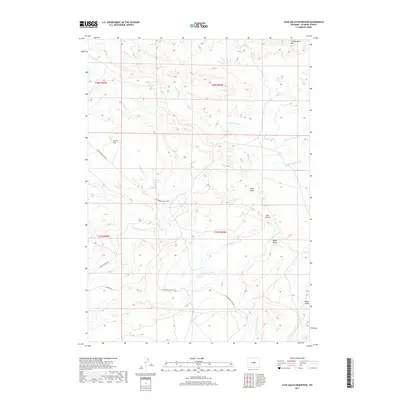
2017 Map of Cave Gulch Reservoir
USGS Topo · Published 2017About this map
Cave Gulch Reservoir and the Burke Reservoir serve as critical water management points in this arid stretch of Natrona County. The landscape is defined by the drainage systems of Cottonwood Cr and the S Fork Powder River, which carve through the high plains. Movement through this region is largely dictated by historical routes and ranching access, specifically the Cottonwood Stock Trl which traverses the northwestern corner near Cactus Flat. The map reveals the intricate topography of the high desert, where named features like Cottonwood Rim and Okie Draw provide navigational markers across the township lines. Local transit is limited to a few established paths such as Flory Sullivan Rd and Barron Rd, reflecting the sparse settlement pattern and primary land use for livestock and water conservation during the early 21st century.
Find a feature on this map
16 named features on this map. Tap any name to fly to it.
Don’t see what you’re looking for? This feature index may not catch every label — zoom into the map to look around manually.
Map Details
Editions of this 2017 Cave Gulch Reservoir Map
This is the sole edition of this map. No revisions or reprints were ever made.
Other maps of this area

1955 · Arminto
USGS Topo · 1:250,000

1958 · Arminto
USGS Topo · 1:250,000

1962 · Arminto
USGS Topo · 1:250,000
1968 · Notches Dome
USGS Topo · 1:24,000

1968 · Big Sulfur Draw
USGS Topo · 1:24,000
1968 · Anderson Draw
USGS Topo · 1:24,000
1968 · Natrona
USGS Topo · 1:24,000

1968 · Flat Top Hill
USGS Topo · 1:24,000
1968 · Powder River
USGS Topo · 1:24,000
1968 · Three Buttes
USGS Topo · 1:24,000