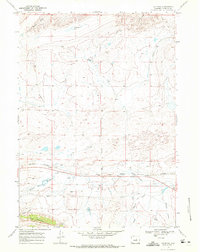
1968 Map of Natrona
USGS Topo · Published 1972About this map
Natrona and the surrounding high plains are defined by a sparse but functional network of transportation and water management late in the 1960s. The Burlington Northern railroad corridor serves as the primary east-west spine of the area, paralleling the Middle Fork Casper Creek. This rail-and-water pairing indicates the essential infrastructure required to support life and industry in this arid landscape. To the north, the terrain is marked by specific human imprints like the Strip Mine and the Old Potters Place, suggesting earlier homesteading and mineral extraction efforts.
Find a feature on this map
18 named features on this map. Tap any name to fly to it.
Don’t see what you’re looking for? This feature index may not catch every label — zoom into the map to look around manually.
Map Details
Editions of this 1968 Natrona Map
This is the sole edition of this map. No revisions or reprints were ever made.
Other maps of this area

1951 · Emigrant Gap NW
USGS Topo · 1:24,000

1951 · Square Top Butte
USGS Topo · 1:24,000

1951 · Reid Canyon
USGS Topo · 1:24,000

1955 · Arminto
USGS Topo · 1:250,000

1955 · Casper
USGS Topo · 1:250,000

1958 · Casper
USGS Topo · 1:250,000

1958 · Arminto
USGS Topo · 1:250,000

1962 · Arminto
USGS Topo · 1:250,000

1962 · Casper
USGS Topo · 1:250,000

1968 · Reynolds Reservoir
USGS Topo · 1:24,000