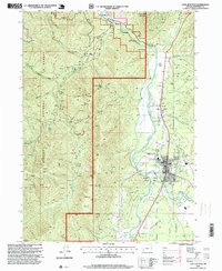
1996 Map of Cave Junction
USGS Topo · Published 1999About this map
Cave Junction and the historic settlement of Kerby center this mid-1990s study of the Illinois Valley in Josephine County. The landscape is a complex intersection of resource extraction and preservation, defined by the Siskiyou National Forest and the protected corridor of the Illinois Wild and Scenic River. Evidence of the region’s long-standing mining history is visible in the numerous Prospect sites and Prospects scattered across the steep drainages of Days Gulch and Madison Gulch. Water management for the valley’s agriculture and industry is marked by features like Pomeroy Dam and the Gravel Dam near the confluence of the East Fork and West Fork of the Illinois River. Cultural landmarks including the Laurel Cemetery and local landmarks like Sauers Flat provide essential geographic markers for researchers tracing the development of this southwestern Oregon community.
Find a feature on this map
50 named features on this map. Tap any name to fly to it.
Don’t see what you’re looking for? This feature index may not catch every label — zoom into the map to look around manually.
Map Details
Editions of this 1996 Cave Junction Map
This is the sole edition of this map. No revisions or reprints were ever made.
Other maps of this area

1917 · Kerby
USGS Topo · 1:125,000

1918 · Kerby
USGS Topo · 1:125,000

1945 · Kerby
USGS Topo · 1:125,000

1954 · Cave Junction
USGS Topo · 1:62,500

1954 · Selma
USGS Topo · 1:62,500

1954 · Chetco Peak
USGS Topo · 1:62,500

1954 · Pearsoll Peak
USGS Topo · 1:62,500

1955 · Medford
USGS Topo · 1:250,000

1957 · Medford
USGS Topo · 1:250,000

1958 · Medford
USGS Topo · 1:250,000