
1951 Map of Cave Mountain
USGS Topo · Published 1951About this map
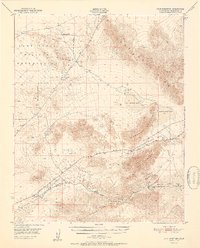
The Union Pacific railroad carves a lifeline through this arid Mojave landscape, following the path of the Mojave River as it reaches its final destination at the Mojave River Sink. This mid-century survey captures a network of rail-dependent desert outposts including Dunn, New Dunn, Afton, and Midway, which served the logistics of the high desert. To the north, the Camp Irwin Military Reservation occupies a significant portion of the territory, its approximate boundaries stretching across the rugged Soda Mountains. The hydrology of the region is defined by ephemeral basins like West Cronese Lake and East Cronese Lake, separated by the Cronese Mountains. The Arrowhead Trail and various beacon sites indicate the early infrastructure supporting transcontinental travel and navigation across the Cronese Valley before the modernization of the interstate system.
Find a feature on this map
29 named features on this map. Tap any name to fly to it.
Don’t see what you’re looking for? This feature index may not catch every label — zoom into the map to look around manually.
Map Details
Editions of this 1951 Cave Mountain Map
2 editions found
Other maps of this area

1933 · Avawatz Mountains
USGS Topo · 1:250,000

1947 · Trona
USGS Topo · 1:250,000

1948 · Red Pass Lake
USGS Topo · 1:62,500

1948 · Trona
USGS Topo · 1:250,000

1948 · Alvord Mountain
USGS Topo · 1:62,500

1948 · Cave Mountain
USGS Topo · 1:62,500

1948 · Tiefort Mountains
USGS Topo · 1:62,500

1951 · Tiefort Mountains
USGS Topo · 1:62,500

1951 · Alvord Mountain
USGS Topo · 1:62,500

1951 · Red Pass Lake
USGS Topo · 1:62,500