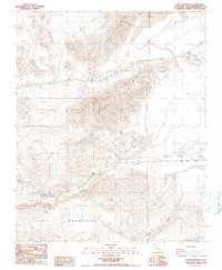
1986 Map of Cave Mountain
USGS Topo · Published 1986About this map
Cave Mountain stands as the central topographic anchor in this San Bernardino County desert landscape, where the Mojave River Wash cuts a distinct path through the arid terrain. The map documents a critical corridor of infrastructure, featuring a prominent Pipeline and Transmission Line that traverse the valley floor between the Cronese Mountains and the northern reaches of the Cady Mountains. Settlement is sparse, limited to the rail-aligned points of Afton and Baxter, which sit along the edges of the Afton Canyon Mojave River. This 1980s survey captures the region's industrial and geological character, marked by numerous Prospects, Mine sites, and a Gravel Pit. The hydrologic transition at East Cronese Lake and the broader Cronese Lake Valley illustrates the complex drainage patterns typical of the Mojave's interior basins.
Find a feature on this map
17 named features on this map. Tap any name to fly to it.
Don’t see what you’re looking for? This feature index may not catch every label — zoom into the map to look around manually.
Map Details
Editions of this 1986 Cave Mountain Map
2 editions found
Other maps of this area

1933 · Avawatz Mountains
USGS Topo · 1:250,000

1947 · Trona
USGS Topo · 1:250,000

1948 · Trona
USGS Topo · 1:250,000

1948 · Cave Mountain
USGS Topo · 1:62,500

1951 · Cave Mountain
USGS Topo · 1:62,500

1953 · San Bernardino
USGS Topo · 1:250,000

1953 · Trona
USGS Topo · 1:250,000

1955 · Cady Mountains
USGS Topo · 1:62,500

1955 · Broadwell Lake
USGS Topo · 1:62,500

1956 · San Bernardino
USGS Topo · 1:250,000